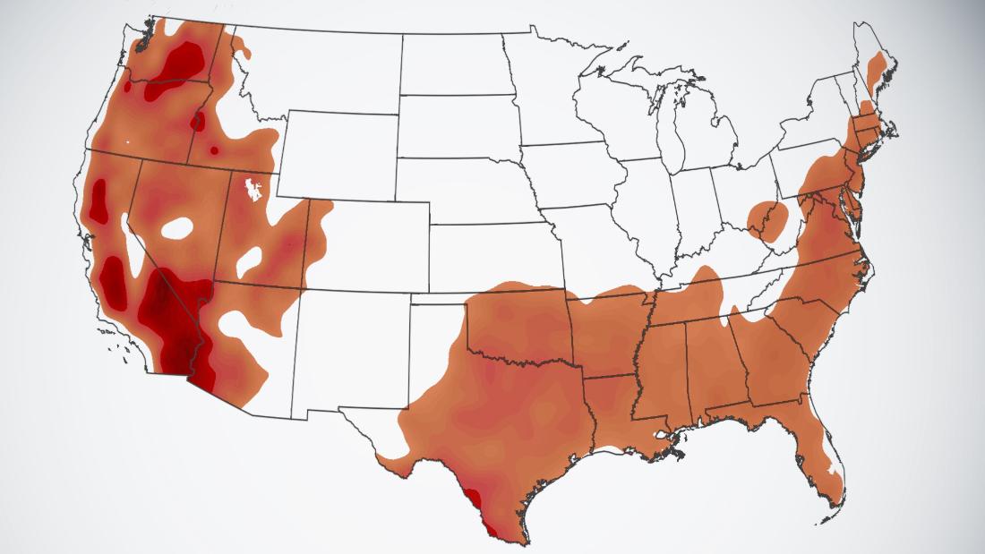
Almost 80 million people remain under heat alerts Friday in the Northeast, Southwest, and Northwest.
Persistent heat has tormented the Northwest throughout the summer, and the latest heat wave has already broken more temperature records.
“Today could be the hottest day in the Northwest, with Seattle in the mid-90s and Portland topping 100 degrees,” CNN meteorologist Dave Hennen said on Friday.
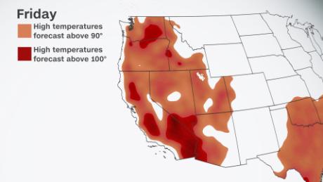
The barrage of 15 to 20 degrees above average temperatures will subside slightly in the coastal areas by Saturday as the winds shift from the west to carry cooler Pacific air into the region. The eastern interiors of Washington state and Oregon continue to feel the heat throughout the rest of the weekend.
The past week has seen high temperatures remain above the 90s in the Northwest, and some areas in Washington state saw records fall.

“The term thrown about back then was heat dome where we just had this high pressure set over us for quite some time which built up to this, whereas this is not going to stay over us for quite so long,” said Steve Reedy, a meteorologist for the NWS in Seattle.
The weather pattern was different in the extreme June event, placing a massive dome of high pressure referred to as a “heat dome” over the Northwest, essentially creating a pressure cooker elevating temperatures to extremes.
This week’s weather still has an area of high pressure bringing hot temperatures, but it is much weaker. In addition, the offshore winds pushing hot air from interior portions of the state towards the coast are weaker. Relief will come by the end of the weekend as the winds shift onshore, bringing cooler air from the ocean inland.
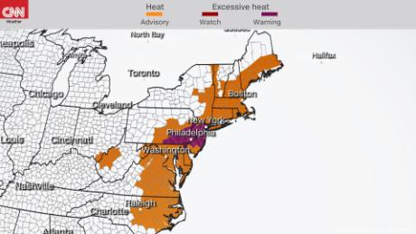
Northeast coast languishes in the humid heat
Heat alerts continue up the Northeast coast Friday, including cities like Philadelphia, Washington, DC, New York and Boston with high temperatures in the 90s combined with humidity, making the “feels like” temperatures even hotter.
The combination of hot air and relative humidity will push heat indices into the triple digits across the coast.
“Another day of high humidity and hot temperatures creating high heat indices well over 100 degrees Fahrenheit is expected, and heat advisories are in effect from North Carolina to Maine and also into portions of West Virginia, with excessive heat warnings embedded in the northern Mid-Atlantic,” the WPC said.

Philadelphia and New York City are included in the excessive heat warnings Friday where heat indices could reach 110 degrees.
In such densely populated urban areas, temperatures can quickly rise 15 to 20 degrees above the surrounding regions. When coupled with moisture in the area, the heat index increases substantially.
Heat index values are an indicator of what the air feels like when the air temperature and moisture content are taken into account. Sweat helps cool the human body when it gets too hot, but humidity prevents sweat from evaporating, making the body even hotter.
The heat and moisture will fuel storms in the region Friday afternoon and evening through Saturday.
Friday will be the last day of extreme heat in the Northeast. The heat in the region is forecast to let up by the beginning of the weekend as a cold front pushes through on Saturday, leaving more seasonal temperatures behind.