Tropical warnings likely to be issued for Puerto Rico with storm formation possible in the Atlantic Monday
The first named tropical system in the Atlantic since early July could form by Wednesday, and tropical storm warnings are likely to be issued in Puerto Rico and other Caribbean locations on Monday.
Tropical storm watches are issued when tropical storm conditions are expected within the next 48 hours, while tropical storm warnings are issued when the same conditions are expected within only 36 hours.
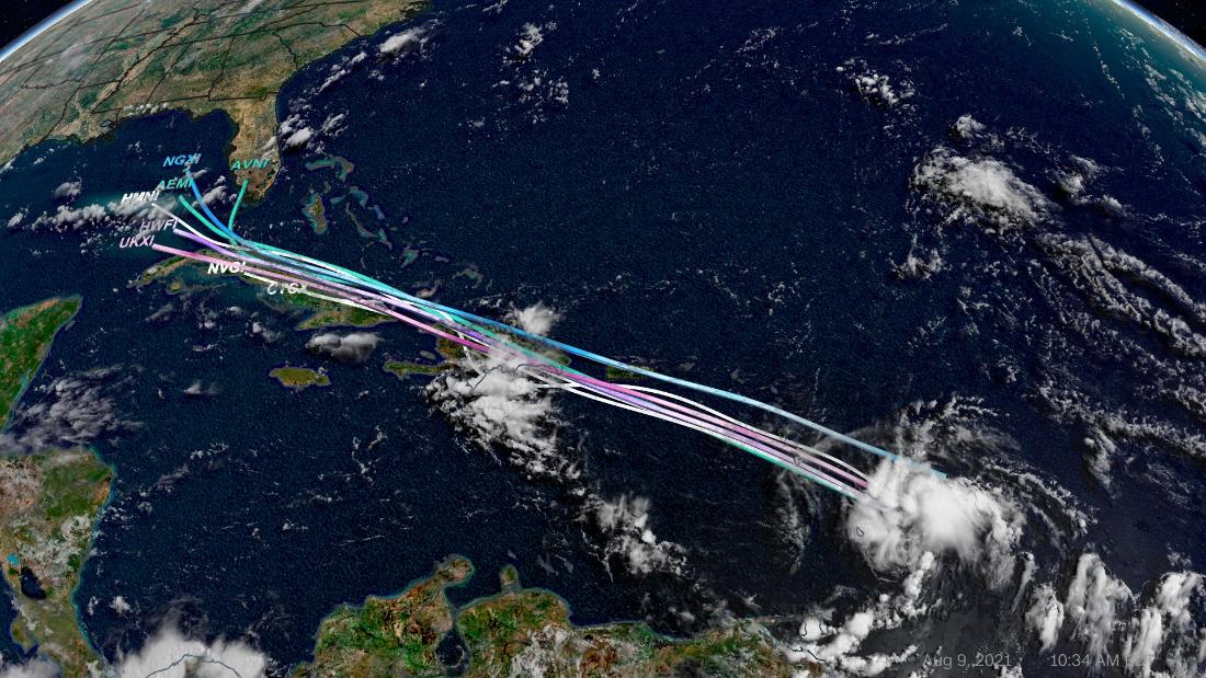
The disturbance is becoming a more concentrated collection of showers and thunderstorms as it moves west-northwestward at 10 to 15 miles per hour.
As the low-pressure system makes its way toward the Caribbean, the conditions will become increasingly conducive for formation. Warm sea surface temperatures in the region will feed the disturbance and allow it to strengthen.
“The system located just east of Barbados looks better organized this morning, and could reach tropical storm strength before it reaches the Virgin Islands and Puerto Rico tomorrow. Even if this system doesn’t develop into a storm, it will likely bring flooding. Flash flood watches cover all of Puerto Rico and the Virgin Islands where 2-3 inches of rain, with locally higher amounts, is expected,” CNN meteorologist Dave Hennen said.
The NHC has given a 70 percent (high) chance of tropical formation over the next 48 hours for the system, which is expected to bring heavy rainfall and flooding to the Leeward Islands, Virgin Islands and Puerto Rico through Tuesday.
“The disturbance is forecast to reach portions of the Lesser Antilles tonight, then move near the Virgin Islands and Puerto Rico on Tuesday, and be near Hispaniola around the middle of this week,” said the NHC.
A tropical storm is categorized by winds of 39 to 73 miles per hour, while wind speed of 74 mph or above is considered a hurricane.
Land interaction in the Caribbean could help weaken the system upon its approach to the Gulf of Mexico. Any impacts on the United States from the disturbance would occur over the weekend.
Computer models are showing conflicting information about the ultimate path where the storm is heading. Some models are showing the system moving north of Cuba over warmer water, while others show the storm passing over more land masses as it makes its way through the Caribbean.
Aside from the stronger disturbance in the Atlantic, there is currently another area of low pressure close behind the first.
The possibility that the system will develop into a storm is much less likely, with only a 10 percent chance of formation over the next 48 hours and 20 percent over the next five days.
Showers and thunderstorms associated with the disturbance are currently unorganized as it moves toward the west at 10 mph. The system is located hundreds of miles east of the Lesser Antilles in the Atlantic Ocean.